.jpg)
History
LAKE LAWRENCE HISTORY
Lake Lawrence was formed several thousand years ago as the Vashon Glacier retreated from the Puget Sound Region North into Canada. In doing so it left behind a huge boulder approximately 100 yards West of the Intersection of Lindsay Road and 153rd Avenue, near the fire station. The boulder is approximately 15 feet tall. The below photo of this erratic boulder was taken by Barry Halverson in July 2019.
This boulder is known as a glacial erratic, defined as a piece of rock that differs from the size and type of rock native to the area in which it rests.
Photo provided by Barry Halverson
In 1873, a 331-acre lake in southeastern Thurston County was surveyed by D.S.B. Henry. Henry reported that there were between 25 and 30 settlers in the township surrounding the lake, and that some of the settlers had resided upon their property for 15 to 20 years. The lake is divided into two distinct basins. The larger East basin is 277 acres in size while the West basin is 53 acres. The surveyors began with the west-end corner near the shore. It took them three days to accomplish their task. The head man in the field party wrote, “a beautiful sheet of water surrounded by cedar, fir, alder and vine maple”.
Jim Kandel, an early resident, gave the lake its first name – Kandel Lake. At the time the area was surrounded by wildlife. The survey team said deer, grouse and mink were bountiful. Within the lake were many suckers and rainbow trout. Prior to 1951, the lake had perch, bass, catfish, suckers and crappie. In 1951 the lake was rehabilitated and filled with trout only. Many years ago, the lake gained renown as being one of the best fishing lakes this side of the mountains. Today, people still reach limits with trout and bass, but the waters are not filled like they once were.
In 1884, there was a bustling sawmill on the east side. Another mill was operating by the early 1900’s. They were fairly small operations, according to today’s standards, employing about five men apiece. Today there are remaining slabs from the mill’s activity in the waters of the lake. The slabs originated from the mill’s activity. The slabs consisted of a sawed log, trimmed, with bark intact. They were dumped with the sawdust into the lake, and most were 16 feet long. This activity in large part contributed to the heavy, mucky sediment currently found in the lake. Horse and oxen often pulled the logs to the mills. Lee and Dallas Edwards’ mother, Jenny, recalled working at the sawmill when she was ten years old for a dime a day.
In approximately 1888 Sam or Jim (documents identify the first name differently) Lawrence bought the Kandel property, the lakes name was changed to Lake Lawrence. In the lifetime of Lee and Dallas Edwards, early settlers on the lake, many changes have taken place on the lake and the surrounding area. Lake Lawrence West housing development was nearly all trees. So was the land of Scenic Shores development. This land was originally owned by the McKenna Lumber Company. Later it was sold to George DeWitt. George DeWitt’s daughter, Leonna, sold the area to Dallas Edwards, Lee Edwards, Mike Edwards, Larry Shorno and Bob Landon and they developed it into Scenic Shores. Lee and Ruby Edwards developed the Lake Lawrence West area. Wildaire, another housing development, was owned and developed by Bill Goodwin and family.
In 1908 the Olympia Light and Power Company (later bought out by Puget Power) needed more energy. They dammed up the south end of the lake off Pleasant Beach Drive and placed a gate where the lake enters the creek to the Deschutes River. A ditch was also dug from where the Deschutes River flows very near Cougar Mountain Camp into the South end of Lake Lawrence which added sediment to the lake for over 20 years. This diversion dam would raise the lake by about 18 feet at various times. In the fall, when the water would get low in the river, they would open the gate so the waters of Lake Lawrence could supplement the power plant in Tumwater. The power supplied all of the Olympia area. This procedure was used until 1928 when the power plant in Tumwater was abandoned. The land on the lake was given back to the land owners who had joined in and supported the power company in the operation. In 1929 the lake was lowered back down to its present level.
To facilitate the dam and the rise in water level Frank and Jennie Edwards two-story house that now sits adjacent to the Lake Lawrence Lodge had to be moved from down by the lake, up to the hill top by three teams of horses. The resort got its start here on the hill, while the lake was still high. The little general store was in the end building next to the house, now over a century old.
Once called the “Edwards Pavilion”, the Lake Lawrence Lodge was erected in 1923 by Mr. Armstrong, Louie and Albert Reichel, and headed up by J.B. Martin who was a local bridge builder. The dimensions of the all-fir structure is approximately 120’x140’. All logs were felled from off the lake property itself. They were hand peeled and hewn and the steel rods were hand tooled. The fireplace was erected by Frank Noreen from Deschutes Falls. It took about one year to complete the building. This became an extension of Edwards Resort, a fishing and recreational getaway, here on Lake Lawrence.
Fishing was the resorts big draw and the season began in April. Here are some photo’s provided by Lisa Kellejian, granddaughter of H.A. (Art) Trimble from his photo collection showing opening day of fishing season in the 1950’s.
In 1948, Lee Edwards and his wife, Ruby, began running the resort and dances. Besides the 12 cabins there were at least 75 camping spots and 110 hand-built wooden boats. Lee built a 20-foot water slide that became quite an attraction in those days. The season started in April, and ended after duck season in the middle of January. An end to the big dances came around 1960.
Around the late 1960’s and early 1970’s Lee Edwards dug the canal around a five acre+ plot of land, belonging to the Edwards family, that was mostly wetlands forming the island on the northwest end of the lake, commonly referred to as “Goat Island”. Around the same time the two bridges, one a footbridge and the other a car bridge were then constructed to make the island accessible. Goats were purchased and placed on the island and cared for by local residents who also built a shed for winter protection.
These community volunteers also provided feed and the services of a veterinarian. The goats kept the island trimmed of vegetation and the bridges made it possible to walk about and enjoy the island. Unfortunately, after several years a large pack of dogs attacked and killed the goats and a few years after the bridges were taken down due to safety concerns. The Lake Lawrence Community Club, who own the Island Property, also still own the access points to the Island where the previous bridges were. The club has been working since 2010 to rehabilitate the island and has long range plans to reconstruct at least one of the bridges.
In 1973, the over 50-year-old resort closed, and the camping era came to an end. The resort property is now enjoyed by many private property homeowners. The café, playground, swimming area, and Edwards Pavilion became part of the Lake Lawrence Community Club, which still maintains these facilities for the benefit of their members. The lodge is also available to the community at large for all types of events to include weddings, anniversaries, birthdays, family reunions, and any other event.
Although much remains the same, a few necessary improvements have been made since the first dance in the ‘20s. This historically unique building holds many weddings and special occasions every weekend of the year.
Music and laughter have penetrated these walls for decades. The floors have endured many nights of dancing feet, and wonderful memories still linger, as tears of joy continue to flow thanks to the many volunteers of the Lake Lawrence Community Club.
From the 1980’s to early 2000’s the Lake Lawrence Community Club worked with the Washington Fish and Wildlife to raise Rainbow Trout in a stock pen at the Community dock. Each year approximately 2,000 trout were raised by community volunteers who fed and cared for the fish daily. When they reached maturity (6 to 10” in length) they were released into the lake. This process was stopped once the Department of Fish and Wildlife started stocking the lake on a regular basis.
Photo provided by Dave & Arvis Olson
The Seattle Inboard and Outboard Racing Associations started racing on Lake Lawrence on or about the Spring of 1976. They have raced every year except 2001 following the 28 February 2001 Nisqually Earthquake that reached a magnitude 6.8 causing water levels in the lake to drop to record lows. The Seattle Inboard Racing Association was unable to race in the Spring of 2015 due to numerous Yellow Flag Iris Floating Islands in the lake measuring 20x30 feet in size causing a hazard to navigation and racing.
Race photo provided by Skip Meredith
Races are run on various course lengths from ¾ mile to 1 2/3 mile recognized by the American Power Boat Association and the Union Internationale Montonautique. Almost every class in both the Inboard and Outboards has set a record on the lake. Lake Lawrence is one of those “just right” lakes. It is big enough for the course, sheltered from wind, not very deep and disperses wave action quickly. Most racers know the reputation of the lake as having prime racing conditions to set records and come from all across the county to race on Lake Lawrence. Some class records are broken every year.
In the 1990’s the Fourth of July Annual Boat Parade was started. This event has grown from a dozen boats to over 40 decorated and colorful boats and other floating craft. The event starts at noon from the Lake Lawrence Community Club boat docks and travels counterclockwise around both the main and little lake until everyone ends back at the start point.
Lake Lawrence is a shallow lake ranging in depth from an average of 8-10 feet to 26 feet at its deepest point. Currently Lake Lawrence has approximately 700 parcels/lots. Of this approximately 165 are lake front, 15 are canal front, and 520 are upland or parcels/lots located within home owners’ associations that have their own lake access by way of a community boat launch and park within each of the three larger associations (Lake Lawrence Community Club, Scenic Shores and Wildaire). In 2015 another development on the southeast end of the lake, Lisa Lane, was developed with six - 5 acre lots.
There is one public boat launch on the southwest end of the lake at the end of Pleasant Beach Drive managed by the Washington Department of Fish and Wildlife and is adjacent to undeveloped land acquired by Thurston County in 1988. In September 2019 the public boat launch was renovated with improved facilities, parking, boat dock and ramp.
Currently there is no stream or other above ground water source to feed the lake. The lake has numerous springs that feed the lake from the bottom. The old dam/weir in the West basin (little lake) that was built in 1908 by the Olympia Light and Power Company still exists, but is now located on a private lake front parcel. The weir is over 20’ tall and the top can be viewed from Pleasant Beach Drive.
When the water level of the lake raises above its high water mark it overflows into a stream bed through the dam shown below to the weir. There are four 2x12” planks that can be removed one at a time to lower the water level, if needed, to allow the excess water to travel down the stream bed through the weir and across the farm property to the west eventually emptying into the Deschutes River approximately 1 mile from the weir.
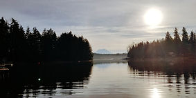
Photo provided by Barry Halverson. View taken from West (Little) Lake facing northwest
This history is made possible by articles and notes from many sources, including:
1985 article from Nisqually Valley News
An unknown author of an article posted in the Lower Lodge of the Lake Lawrence Community Club
An article titled, “Within These Walls - A GLANCE INTO THE PAST”, by Neo Brown, Lee Edwards’s daughter
Racing Association information provided by Russ Dodge, Chief Surveyor for The American Power Boat Association and Skip Meredith, Member American Power Boat Association and Lake Lawrence Lake Management District
If you have photos/articles/memories you would like to share to enhance/expand upon this history please contact Barry Halverson at lakelawrence750@gmail.com or 253-341-6059.


